Why in news
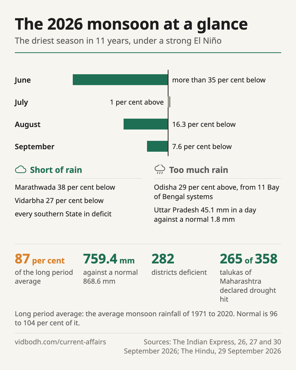
The southwest monsoon ended on 30 September 2026 at 87 per cent of the long period average, the driest season in 11 years, and Maharashtra declared drought in 265 of its 358 talukas on 26 September.
- 87 per centof the long period average: 759.4 mm against 868.6 mm
- 13thdriest monsoon since 1901
- 282districts deficient, over 38 per cent of the country's area
- 265 of 358talukas of Maharashtra declared drought hit
Background
- The long period average (LPA) is the average monsoon rainfall over 1971 to 2020, and a season counts as normal when it falls between 96 and 104 per cent of it.
- El Niño is the abnormal warming of the surface waters of the equatorial Pacific, which suppresses Indian rainfall, while La Niña favours it.
- El Niño is declared on the Niño 3.4 index, the sea surface temperature anomaly in the central and eastern equatorial Pacific, which stood at +2.51°C.
Why the season was uneven
- Low pressure systems from the Bay of Bengal were active on 77 days against a normal 57, which kept central India wet despite El Niño.
- The Madden Julian Oscillation (MJO), a band of rain bearing clouds with a period of 30 to 60 days, stayed unfavourable over the south, so every southern State ended in deficit.
- Inside Maharashtra the deficit was 18 per cent, but Marathwada was 38 per cent short and Vidarbha 27 per cent, both rain shadow regions.
Drought and flood in the same season
- Odisha ended with a 29 per cent excess, brought by 11 Bay of Bengal systems one after another, which left the soil saturated and turned each new spell into runoff.
- A deep depression meeting a Western Disturbance flooded Uttar Pradesh in the last week of September, as the monsoon was withdrawing.
What lies ahead
- The India Meteorological Department (IMD) projects El Niño effects until at least March 2027.
- A strong El Niño generally favours a wetter northeast monsoon over the southern peninsula, though not in every such year.
- Long duration arhar flowers in October and fills its pods in November, so a dry spell then causes terminal moisture stress, and low soil moisture may hold back rabi sowing.
The way forward
- Build drainage for repeated intense downpours, since one day and five day rain bursts are becoming more common even as heavy rain days decline.
- Act on the forecast in crop planning: short duration pulses, millets and oilseeds where the season is expected to fail.
- Document the ecological effects of this El Niño, as 188 Indian scientists have asked, since a coral reef needs about a decade to recover from bleaching.
Prelims facts
- The LPA is calculated over 1971 to 2020; normal is 96 to 104 per cent of it.
- A Western Disturbance is an east moving extra tropical cyclone that gathers moisture from the Mediterranean, Black, Caspian and Arabian Seas and is carried by the subtropical westerly jet stream.
- The Indian Ocean Dipole can dampen or amplify El Niño's effect on India.
- The MJO moves with a period of 30 to 60 days.
See also: Drought declaration · Swell surge
Sources: The Indian Express, 30 Sep 2026: Monsoon ends with 13% rain deficit, driest year in a decade (opens in a new tab) · The Hindu, 23 Sep 2026: A strong ‘El Nino’ and northeast monsoon: What lies ahead for Tamil Nadu? | Explained (opens in a new tab) · The Hindu, 20 Sep 2026: Ecologists urge scientists and policymakers to study imminent ‘Super’ El Niño to prepare for the future (opens in a new tab) · The Hindu, 29 Sep 2026: Waves of rain: on Odisha and intense rain events (opens in a new tab) · The Indian Express, 26 Sep 2026: Behind Maharashtra drought crisis, sharp regional variation in rainfall (opens in a new tab) · The Indian Express, 27 Sep 2026: What is causing the flood-like situation in Uttar Pradesh? (opens in a new tab)
Earlier coverage: The 2026 monsoon and El Niño · The monthly magazine, September 2026